 |
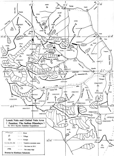
| Outline of Lenak Nala and Giabul Nala |
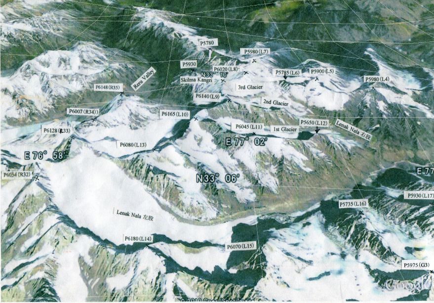 |
| Google Earth Photo of Lenak Nala |
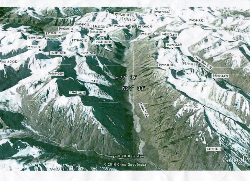 |
| Google Earth photo of Giabul Nala |
Paradise of Hidden Virgin Peaks in Zanskar South
( 2011 Exploration of Lenak Nala & Giabul Nala )
Kimikazu Sakamoto
In 2009, we explored Reru Valley in Zanskar and could find many unknown virgin peaks in this area. We presumed that there might be another hidden valleys in Zaskar South of Indian Himalaya, which no mountaineers had ever explored to identify the unknown mountains.
I contacted with Mr. Harish Kapadia, one of the leading explorers of Himalayan Club and asked him whether any exploration record about Lenak Nala and Giabul Nala had been reported or not. He kindly replied to me that he had never heard any exploration record in these valleys.
We planned to have expedition to explore Lenak Nala and Giabul Nala last summer in 2010. But unfortunately, at night of August 5th when we arrived at Delhi, the awful landslide disasters were caused by the sudden cloudburst in Ladakh. We were so surprised to know on TV that many people died and there were still lots of missing people, and that many houses and bridges were destroyed. We decided immediately to give up our expedition under such a chaos of the miserable disasters and informed our decision to Mr. Tsewang Yongphel, President of our tours operation company "Hidden Himalaya", who luckily escaped from the disasters.
As a second challenge, we went to Lenak Nala and Giabul Nala during August 4th ~ September 15th, 2011, to explore the unknown and untrodden peaks with five members, Mr. Akira Taniguchi, Mr. Toshio Ito, Mr. Sachiyuki Hatta, Mr. Mitsuhiko Okabe and me, the leader Mr. Kimikazu Sakamoto. We are senior expedition team with 70~73 years old members.
There are many mountains in Lenak Nala and Giabul Nala, 15 peaks over 6000m, 10 peaks of 5900m, 8 peaks of 5800m and 15 peaks of 5700m. We put the tentative mountain names like L1, L2 and L3 to mountains of Lenak Nala and G1, G2 and G3 to Giabul Nala mountains on our Outline Map, so that we may avoid confusion in our identification of the mountains.
In order to get easier identification of many unknown mountains in Lenak Nala and Giabul Nala, we got a lot of Google Earth 3D photographs and put the identification labels on the photos.
|
| Outline of Lenak Nala and Giabul Nala |
|
| Google Earth Photo of Lenak Nala |
|
| Google Earth photo of Giabul Nala |
We arrived at Delhi in the morning of August 5th by TG323 and spent three days, visiting IMF (Indian Mountaineering Foundation) Head Office and having half day sightseeing in Delhi.
On August 7th, we moved to Leh by the morning flight from Delhi. We were surprised to find the town of Leh and the nearby area were already almost recovered from the previous year landslide disasters, with newly constructed buildings and private houses. We stayed in Leh for two days during August 7th and 8th, for shopping and visiting Central Institute of Buddhism Studies, Tibetan Children School in Choklamsar and so on.
After three days car tour from Leh, we finally reached Padam on August 11th via Hanu and Dah, Kargil, Sanku and Pensi La. In Padam, we enjoyed Sani Gompa Festival on August 12 and started our trekking on August 13th to Shanka, the entrance for Lenak Nala.
1. Padam - Shanka:
August 13th: 10:50/Padam - 14:20/Dorzong (3803m, N33-17.28.6, E-77-01-00.9).
After we visited Tsewang's mother at Hongmet near Karsha Gompa in the morning, we left Padam before noon. The construction of traffic road between Padam and Darcha via Singo La has been proceeded by BRO (Board of Road Organization)in these several years. In 2007 when we explored Reru Valley, the traffic road available for car was opened only up to Reru Village. But now, we could reach Dorzong by mini-bus. Two horsemen and 10 hoses should come to this small village Dorzong in the afternoon. But one horseman called "Big Tenzing" with 7 horses did not show up on that day.
August 14th: 7:30/Dorzong - 12:00/Tsetan(3800m, N33-14-56.6, E77-03-58.3).
Big Tenzing did not come to Dorzong in the morning. We hired an extra horseman with 3 horses and went to Tsetan. It was 6.30pm in the evening when Big Tenzing and 7 horses arrived at Tsetan. Our guide Tsewang got angry and made the heavy complain to him.
August 15th: 7:20/Tsetan - 9:25/Kalbox - 10:15/Zamthang - 15:45/Testa (3968m, N33-10-41.5, E77-10-06.3).
We could see again the long attractive mendan and the wonderful Rock Painting at Zamthang. When I lived in South Africa during 1987 ~1993, I could often see Rock Painting by Bushmen in Drakensberg area when I went there for mountaineering.
August 16th: Rest day at Testa (Rainy and cloudy day).
August 17th: 6:40/Testa - 7:40/Kuru - 15:30/.Shanka (4234m, N33-04-51.6, E77-09-90.4).
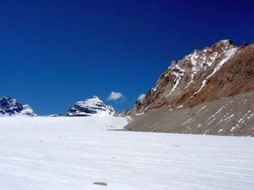
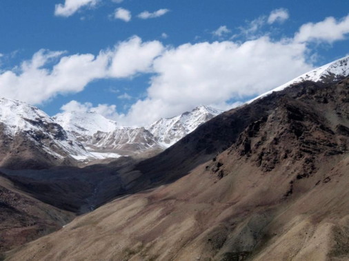
We finally arrived at Shanka which is the entrance village to Lenak Nala. Shanka is the small village with only four houses and about 20 people. Lenak Nala was the strong river with rapid stream water. There was the good bridge to cross from right side to left side for pasturing Yaks.
2. Exploration of Lenak Nala:
August 18th: 7:40/Shanka - 9:20/Grazing Ground -12:30/Camping Ground (4519m, N33-06-50.8, E77-06-45.7).
We could see the very open and wide Lenak Nala from Shanka village. We crossed the bridge to the left side of Lenak Nala from the village and enjoyed pleasant walking on the green meadows. We found many nice grazing grounds where Yaks were enjoying their lives. Looking the attractive rock mountain P5665(L1) on our right side, we came to the wonderful place with small pond in the pasture. We found Yak Hut on the big and flat grazing ground, but there was no pure water. We decided to set up our camping site at the next pasture which had good clean water stream. From this camping site, we could see the very colorful mountain P5837(L2).
August 19th: 8:20/CS - 10:30/Junction of left branch and right branch of Lenak Nala (4620m, N33-06-47.6, E77-04-55.3) - 12:30/CS.
We had a very short walk to the junction of left branch and right branch of Lenak Nala to check the available route to the right branch. There was the water fall in the right branch about 300m above the junction. But, we judged that it was possible for us to use horses to carry up our baggages on the right side grassy slope to the higher plateau.
There were many beautiful flowers between the camping site and the junction, including blue poppies. For acclimatization, we stayed at the same camping site on this day.
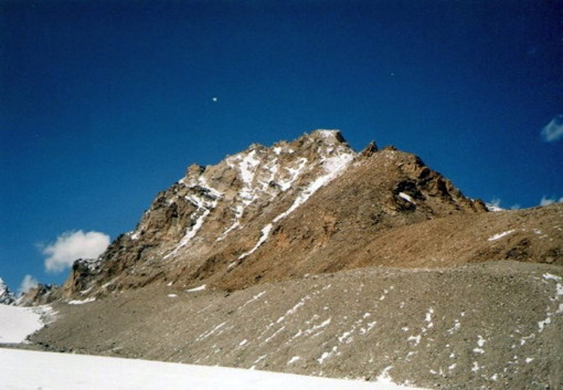
I climbed up the back yard hill up to 4780m and could see in the right branch of Lenak Nala P6020(L8) and Skilma Kangri (5970m?) which was climbed by Britain Expedition in the autumn of 2009.
August 20th: 7:10/CS - 8:10/Junction of left branch and right branch - 11:30/Lenak Nala BC (4718m, N33-06--09.4, E77-3-59.7).
We intended to set up our Lenak Nala Base Camp around 4830m. But, our horsemen unloaded our baggages at the lower altitude, insisting that there was no green glasses for feeding horses. It was my big mistake as expedition leader. I should have ordered our horsemen to carry up our baggages up to about 4800m just before the glacier tongue, allowing them to go down with their horses to the lower glassy place.
August 21st: 7:10/Lenak Nala BC - 14:00/Lenak Nala Glacier 5191m (N33-05-01.8, E-77-00-58.0) - 19:00/Lenak Nala BC.
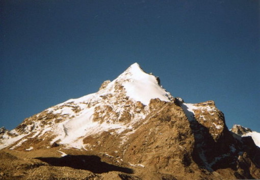
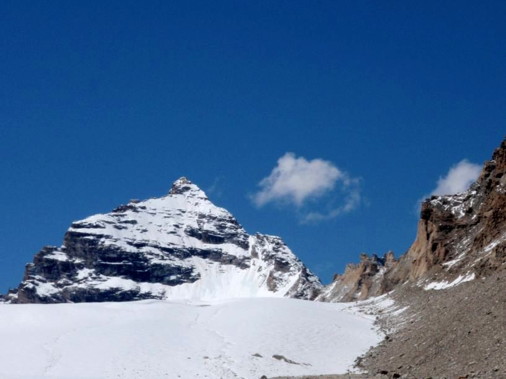
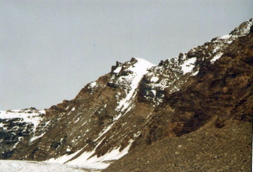
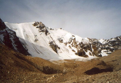
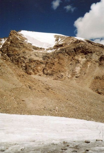
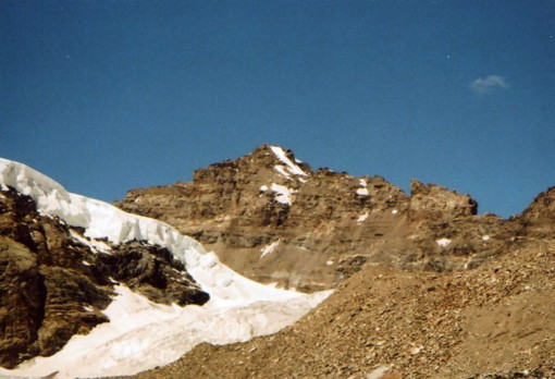
Today is the exciting day for us to explore several untrodden peaks over 6000m in Lenak Nala Glacier. Soon after leaving our Base Camp, we could see the beautiful snow peak mountain P6070(L15) and the big rock wall mountain P6180(L14) on our left side.
The beautiful elegant mountain P6070(L15) can be called as Prince of Lenak or Lenak Kangri. The big rocky mountains maybe is King of Lenak.
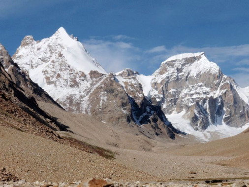
We climbed up the moraine and saw the pyramidal peak P5975(G3)in the glacier of P6070(L15).
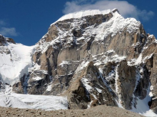
We climbed up several moraine hills with unstable stones and reached the glacier. For safety sake, we walked on the glacier with tight rope. On our right side, we could see the rocky front mountain of P6080(L13) and the snowy main peak of P6080(L13) over the moraine.
When we passed the west end of P6180(L14), we could see P6128(R33) which is the border mountain between Reru Valley and Lenak Nala. Just before P6180(R33, there was anothher rock mountain P6054(R32) which looks rather tough mountain to climb.
Time was already 2:00 pm. We decided to go down to BC, as we were afraid we could not reach our BC before sunset as we are old age slow walkers. We struggled in walking down unstable moraine and reached BC at 7:00 pm, being exhausted.
On this day, we could recognize five unknown 6000m peaks, P6070(L15), P6180(L14), P6080(L13), P6128(R33) and P6054(R32).
August 22nd: Rest day at Lenak Nala BC.
We had rest as we were so tired on the previous day. It was my regret that I made the mistake as leader in setting up our base camp at the lower place than expected altitude. If we could not come down to Base Camp before sunset, it would be dangerous for our elderly mountaineers.
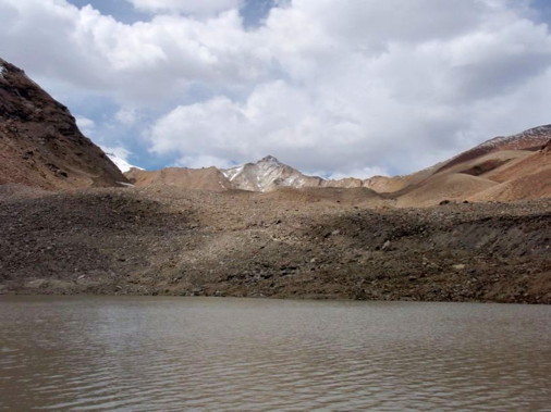
August 23rd: 6:10/Lenak Nala BC - 7:30/Junction of left and right branch - 8:55/Plateau of right branch (4757m) - 12:00/Lenak Nala Right Branch Base Camp 5040m, M33-07-37.6, E77-04-06.8).
We walked on the right side of Lenak Nala and reached the junction of left and right branch. It was rather easy walk for us to go up on the grassy slope on the right side of the river, looking the water fall on our left side. Then, we went up on the right side of several moraines in Lenak Nala Right Branch. After crossing the stream of the right branch to the left, we reached our camp site near Glacier Lake.
August 24th: 6:50/Lenak Nala Right Branch BC - 9:20/Glacier 5245m (N33-07-18.1, E77-03-06.1) - 12:00/BC.
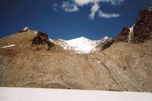
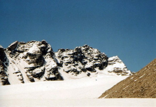
We went to 1st Glacier of Lenak Nala right branch. Over the glacier lake, we could see P6020(L8) and P6165(L10) which was protected by steep icy wall. After walking on the moraine, we saw the rocky mountain P6140(L9) in the right side of 1st glacier. On our left side, there was P6045(L11) which had icy steep wall.
As we could see four unknown 6000m peaks, we went down to our BC because the weather was getting worse.
August 25th: 7:25/Lenak Nala Right Branch BC - 9:10/Junction of left and right branch - 12:00/Lenak Nala Camping Ground (4519m, N33-06-50.8, E77-06.45.7).
As we could see four 6000m peaks in the right branch of Lenak Nala which we expected, we decided to go down the right branch and to move to Giabul Nala. As the lenak Nala near junction was so rapid with much water, we crossed the stream safely on the horse together with horseman. On the afternoon, we took rest and relaxed.
 |
 |
|
From left, P6070(L15) and P6180(L14) in the left branch of Lenak Nala
|
P6070(L15) on the left branch of Lenak Nala
|
 |
 |
|
P6180(L14) in the left branch of Lenak Nala
|
P6080(L13), The main peak is behind the front rock peak
|
 |
 |
|
P6080(L13) in the left branch of Lenak Nala
|
From left, P6054(R32) and P6128(R33) in the left branch of Lenak Nala
|
 |
 |
|
P6128 (R33) in the left branch of Lenak Nala
|
Center moountain, P6054(R32) in left branch of Lenak Nala.
|
 |
 |
|
P5975(G3) in the left branch of Lenak Nala
|
From right, P6020(L8) and Skilma Kangri in right branch of Lenak Nala
|
 |
 |
|
P6020(L8) in the right branch of Lenak Nala
|
P6140(L9) in the right branch of Lenak Nala
|
 |
 |
|
The right mountain, P6165(L10) in the right branch of Lenak Nala
|
P6045(L11) in the right branch of Lenak Nala
|
3. Exploration of Giabul Nala:
August 26th: 7:30/Lenak Nala Camping Ground - 10:20/Junction with Giabul Nala - 12:00/Opposite Namkha Tokpo (4254m, N33-03-29.9, E77-07-39.3).
As there are many branches in Giabul Nala, we put our tentative names to two big branches. We decided to give the name of Namkha Tokpo to the biggest and long branch which has three 6000m peaks, P6005(G18), P6060(G20) and P6165(G22). Sachi Tokpo was given to the next big branch which has two 6000m peaks, P6078(G14) and P6005(G18).
We walked down to the bridge at Shanka village and crossed over the small hill to enter into Giabul Nala. This river is bigger and wider than Lenak Nala and was the very rapid with much water. It seemed to be impossible for us to cross Giabul Nala.
We proceeded on the right side bank of Giabul Nala and saw several Yak Huts. Many Yaks were enjoying eating glasses on both sides of the grazing grounds.
At one place, we could not walk along side the river and climbed up the steep cliff and traversed about 300 meters on the right side slope.
The rocky mountain P5865(G21) was located at the junction of Namkha Tokpo. We pitched our tent on the other side of Namkha Tokpo. In the evening, several young girls were riding on the horses to take care Yaks. Our young kitchen boys were so excited and trying to talk with them over the wide river.
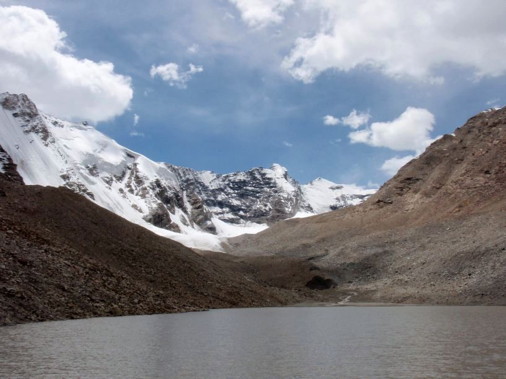
August 27th: 7:10/CS - 10:30/The other side of P5935(G19) - 12:20/Giabul Nala Base Camp (4409m, N33-02-41.0, E77-01-23.0).
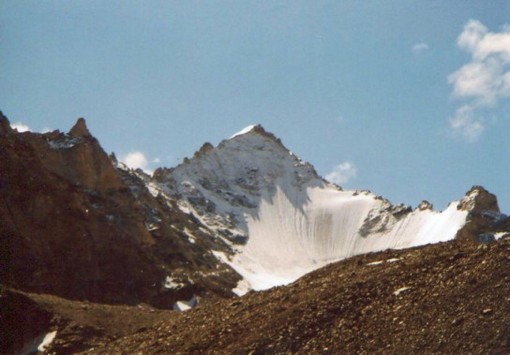
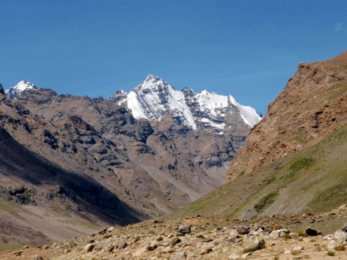
We walked on the right side of wide and open Giabul Nala, saying Namaste to many Yaks. We saw the very challenging peak P5935(G19) stood on the left side of the river. This peak is the very sharp peak with rock and ice and looks difficult to climb. We set up our Giabul Nala Base Camp just opposite P5935(G19).
At the junction of the left glacier and right glacier of Giabul Nala, there was the rock mountain P5686(G8). Two high mountains with snow were seen over P5686(G8). According to the map, there should be P5700(G7) and P5754(G6), but these mountains looked too high, maybe over 6000m.
On the afternoon, Mr. Ito and Mr. Okabe made reconnaissance up to the glacier tongue and found the possible route to climb up the rocky hill on the right side of the water fall.
August 28th: 7:20/Giabul Nala BC - 9:00/Glacier tongue - 11:30/Giabul Nala BC.
We wanted to get into the left glacier of Giabul Nala to see two unknown peaks P6014(G11) and P6078(G14). As it was impossible for us to cross over the rapid stream before glacier tongue, we tried to climb up the icy moraine cliff accumulated with many unstable small stones and then to traverse to the left glacier. I climbed up this unstable moraine cliff and thought we could reach the top without so much difficulty. But our guide and horsemen shouted me I should go down, insisting that it was too risky and dangerous because of falling stones on the unstable moraine cliff. As the weather was not so good with too much black clouds, I decided to follow their advice and give up to explore the left glacier.
It was a regret that we lost our chance to see the unknown peaks P6014(G11) and P6078(G14) in the left glacier.
August 29th: Rain. Rest at BC.
On the afternoon, our guide, kitchen staffs and horsemen constructed the wonderful stone bridge over the rapid stream of the water fall, so that we might cross the river to the left side of Giabul Nala. It was the miracle and splendid work.
August 30th: 7:10/Giabul Nala BC - 7:40/Stone Bridge - 7:50/Junction to Sachi Tokpo - 9:45/4595m in Sachi Tokpo - 12:20/4746m (N33-01.16.0, E77-01.21.0) - 15:45/Junction of Sachi Tokpo & Giabul Nala - 17:45/Grazing Ground CS (4320m, N33-02-40.8, E77-03-42.9).
Only five expedition members are going to explore Sachi Tokpo to identify P6078(G14) and P6005(G18). Our guide, kitchen staffs and horsemen are going down on Giabul Nala to set up our camping site near Grazing Ground.
We crossed the hand-made stone bridge, using rope for safety sake to avoid our slipping down into the rapid stream. After the stone bridge, we walked down on the left side bank of Giabul Nala. Sachi Tokpo had many waves of the steep moraines with unstable stones.
We could see P5720(G15) and P5895(G16) at T-junction of Sachi Tokpo. After climbing up one steep moraine hill, another big moraine was waiting for us. We were struggling in climbing up many moraine hills. P6078(G14) and P6005(G18) can be observed only from T-junction. But, T-junction was still very far. It was already 12:20 pm. As we had to walk another 400~500m to reach T-junction, we decided to go down in order to reach our next camping site before sunset.
It was our big regret to miss these two unknown 6000m peaks in Sachi Tokpo. And, we realized how our walking pace was so slow because of our old age.
We had to cross over Sachi Tokpo at the junction with Giabul Nala. Even branch river like Sachi Tokpo was the rapid stream with much water. We crossed Sachi Tokpo with rope to avoid any kind of risks. Our guide Tsewan came to the junction, in much anxious of our safety.
August 31st: 7:20/Giabul Nala Grazing Ground - 10:45/Yak Hut near Junction with Namkha Tokpo - 11:30/Namkha Tokpo Camping Site (4270m, N33-03-09.6, E77-07-15.7)
We visited Yak Hut near the junction with Namkha Tokpo. The kind woman entertained us with very delicious home made Yak yogurt. She explained that six women selected from each family take care about 200 ~ 300 village Yaks for six days. Then another team with six women succeed next turn. I asked her what their husbands are doing while the women are working hard for grazing Yaks. "Your husbands are drinking Roksi and gambling cards while their wives are working hard ?" She nodded and was laughing out.
She kindly gave us her information that there is the good Yak trail on the left side of Namkha Tokpo.
September 1st: 7:20/Namkah Tokpo CS - 7:50/Crossing Namkha Tokpo - 11:30/Namkha Tokpo Base Camp(4620m, N33-01.01.0, E77-06-53.1) - 13:35/BC - 14:15/Second junction (4750m) - 14:40/BC.
We crossed Namkha Tokpo on horse together with horseman, as the stream was so rapid even in the early morning. There was the good and clear Yak trail on the left side of Namkha Tokpo.
After passing the first small branch from the left side, Namkha Tokpo became very wide. Our guide and horsemen decided to set up our Namkha Tokpo Base Camp on the right side at the foot of the grassy cliff. We agreed to their opinion though we wished to go up higher, as they insisted there was no good spot for camping. We crossed the strong stream on horse to the right side and set up our Base Camp.
On the afternoon, Mr.Ito, Mr.Okabe and I had short hiking up to 4750m, just before another branch under P5840(G25) which is very attractive mountain.
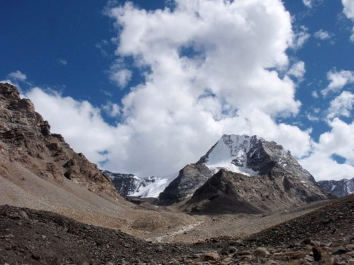
September 2nd: 6:40/Namkha Tokpo BC - 7:20/4750m - 12:00/Foot of P6115(G22)(5075m - N32- 59-30.2, E77-05-18.6) - 16:00/Namkha Tokpo BC.
From the foot of P5840(G25), we could see the overwhelming mountain P6115(G22) at the T-junction. But, many up and down moraines was so strenuous.
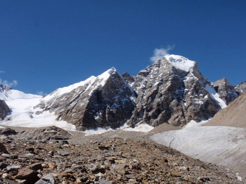
Though we were very exhausted, finally we reached the T-junction just under big rock wall of P6115(G22). From that point, P6005(G18) came to our eyes. And, we could see P6060(G20) at the right side corner of Namkha Tokpo.
All of us were very happy to see these 3 hidden peaks over 6000m in Giabul Nala area, in addition to 9 unknown peaks over 6000m in Lenak Nala area, total 12 peaks all of which maybe untrodden virgin peaks. We shook hands and hugged each other, celebrating our successful exploration in Zanskar South.
We walked down slowly and slowly, recalling our successful exploration though we were very tired. Our guide Tsewam came up to welcome us, being anxious about our return.
September 3rd: 7:08/Namkha Tokpo BC - 9:40/Junction with Giabul Nala - 13:00/Tangso (4133m, N33-04.-37.3, E77-11-25.8).
We enjoyed the easy walking down on the good Yak trail to the junction with Giabul Nala. There were many Yaks on the wide and open grassy natural pasture in Giabul Nala. We arrived at Tangso after lunch. Tangso was the beautiful and wonderful village with big pastures and barley fields, with twelve houses and about sixty village people. We paid our visit to Public School in Tangso and met the teachers. They said that they were teaching 41 students from 5 years old to 18 years old, with six teachers.
We spent seventeen days for exploration of Lenak Nala and Giabul Nala from Shanka to Tangso. We did not see any mountaineers or trekkers and met only several women who were taking care their Yaks. These areas are the wonderful places with the attractive mountains and the beautiful natures, without any garbage like plastic bags, beer cans and glass bottles.
September 4th: Rest day at Tangso.
 |
 |
|
P5935(G19) on Giabul Nala
|
P5840(G25) in Namkha Tokpo of Giabul Nala
|
 |
 |
|
P6115(G22) in Namkha Tokpo
|
P6060(G20) in Namkha Tokpo of Giabul Nala
|
 |
|
|
P6005(G18) in Namkha Tokpo of Giabul Nala
|
|
4. Return trip to Leh via Singola and Tso Kar:
We moved to the foot of Gumburanjan (5320m)on September 5th and went up to Singola Base Camp next day on September 6th. We crossed over Singola (5045m) and walked down the long way to Ramjyak on September 7th. The camping site of Ramjyak was so messy with too much garbage same as four years ago. As we could not endure such messy camping site, we cleaned up Ramjyak Camping Site with our guide, kitchen staffs and horsemen. Our young kitchen staffs constructed the big garbage storage with many big stones to avoid future miserable situation. Any campers will be able to burn the garbage in this stone storage with kerosene after camping.
When we went down to Zanskar Sumdo on September 8th, we were so surprised to find the shovel cars were working to make new traffic road to Singola. Four years ago in 2007, the traffic road was opened up to Palamo.
We went further down to Tukpachan and stayed two nights on September 8th and 9th to wait for our car. We took a car from Tukpachan on September 10th and stayed one night at Tso Kar. Next day on September 11th, we came back to Leh and enjoyed hot shower which we could not take more than one month.
After two days stay in Leh, we took flight to Delhi on September 13th and came back to Japan by Thai Air flight, leaving Delhi 23:30 on September 14th and arriving Osaka via Bangkok next day on September 15h.
We could really enjoy the splendid expedition in Zanskar South and were very happy to have the successful exploration in Lenak Nala and Gibul Nala.
We were very lucky, because of good weather conditions and also the good support of our reliable guide and efficient kitchen staffs.
We hope young climbers will come to Lenak Nala or Giabul Nala to try their first ascent to the attractive virgin peaks which we found in this exploration.