Unknown Hidden Virgin Peaks in Zanskar
Exploration of Temasa Nala, Gompe Tokpo and Haptal Tokpo of Indian Himalaya
Kimikazu Sakamoto
South Zanskar, the north west of Indian Himalaya is the very exciting mountain area with many unknown and untrodden peaks.
In 2009, we explored Reru Valley under the encouraging mental support from Mr. Harish Kapadia of Himalayan Club and enjoyed the successful exploration. I introduced many hidden virgin peaks in Reru Valley area to the climbers over the world through The Himalayan Journal, Japanese Alpine News and The American Alpine Journal.
In 2011, three climbing expeditions who read my exploration report went to Reru Valley and had the successful first ascents. In the summer of 2011, we went to Lenak Nala and Giabul Nala in Zanskar to explore the unknown virgin peaks. Referring my exploration report, three expedition teams went to Zanskar in the summer of 2012 to climb the untrodden peaks which we found in this area.
Scottish Team climbed the virgin peak P6115(G22) in Namkha Tokpo of Giabul Nala, Japanese Alpine Club made the first ascent to P6165(L10) in the right branch of Lenak Nala and Kyoto University Alpine Club climbed the virgin peak P6080(L13) in the left branch of Lenak Nala.
Temasa Nala is the northern valley next to Reru Valley and has been used as the local transportation route for the village people of Padam and other villages in Zanskar to go to Udaipur via Kang La (5468m) and Miyar Nala, and also to go to Kilar via Poat La (5490m). The route from Temasa Nala to Miyar Nala via Kang La has been used also as trekking course. But this course was not used so often, comparing the popular trekking course from Padam to Darcha via Singo La (5045m), because of the rather hard mountaineering route.
In 2007, my friend, Mr. Satyabrata Dam of Himalayan Club, explored Miyar Nala and went down to Temasa Nala crossing Kang La and then went up to Poat La via Tidu Glacier. He introduced the exciting photographs of P6294(T4) and P5995(T6) in Tidu Glacier on The American Alpine Journal 2008. But, so far, I have not heard any news that these peaks were climbed.
Gompe Tokpo is the western valley from Padam. Though the beautiful panoramic view of the peaks surrounding Gompe Tokpo can be seen from Thonde and Karsha, no expedition team has ever entered into the inside of Gompe Tokpo. I could not find any expedition report about the mountains in the sanctuary of Gompe Tokpo.
I thought that most of the mountains in Temasa Nala and Gompe Tokpo area might remain as the untrodden virgin peaks. I contacted with IMF (Indian Mountaineering Foundation) to get their information. Being encouraged by IMF reply that there is no climbing record in IMF book regarding all of the mountains in this area, we planned to explore Temasa Nala and Gompe Tokpo to see and identify the untrodden peaks during June 27 ~ August 2, 2012.
Our exploration team is consisted of four senior members, Mr. Mitsuhiko Okabe (71), Mr. Masaki Shibata (66), Mr. Toshihiro Katsumata (64) and me Mr. Kimikazu Sakamoto (72) as the leader. We requested Mr. Tsewang Yangphel of Hidden Himalaya in Leh to support our expedition same as 2009 and 2011, and he arranged three kitchen staffs, two horsemen and ten horses.
1. Approach to Zanskar :
I left Osaka Japan by Thai Air on June 27 and spent one night at New Delhi, and joined other three members who arrived at Delhi Airport via Beijing in the early morning of June 28 and took the morning flight 9W-2245 at 05:40am to Leh with them.
In the afternoon of June 28, we visited Old Palace and Tsemo Gompa in Leh for acclimatization and had shopping on the market street.
On June 29, we enjoyed Hemis Gompa Tsechu which was the most famous biggest festival in Ladakh and then visited Tikse Gompa.
We used three days during June 30 ~ July 2 to move to Padam from Leh. We spent one night at Lamayuru on June 30 after visiting Likir Gompa, Archi Gompa and Rizong Gompa.
We visited Lamayuru Gompa in the morning of July 1, and then we moved to Purtickchey Turist Bungalow via Kargil. We saw many Indian Army Camps near Kargil.
On July 2, seeing the beautiful Nun (7135m) and Kun (7077m) from Purtickchey we drove to Padam along Suru Valley. At the junction with Shafat Glacier, we could see Z1 (6161m) to which Hokkaido University Japan made the first ascent in 1980.
We are attracted to see the twin rock peaks of P5920 at the top of Pensi Glacier. We had lunch at Pensi La, looking Z3 (6270m)and other 6000m peaks in Darung Drung Glacier and reached Padam around 16:00.
On July 3, we had the rest at Padam for acclimatization and visited Thonde Gompa and Zangla Chomo Gompa. We were pleased to see the beautiful pink wild roses near Thonde and Zangla.
At Thonde, we could have the exciting panoramic view of many peaks surrounding Gompe Tokpo.
On July 4, after visiting Karsha Gompa and Tsewang's mother at Hongche village, we drove to Bardan and set up our camping tents at Bardan Gompa School. Though we brought some gifts from Japan to school children, the school was closed because of the special holiday. So, we asked two young monks of Bardan Gompa to give them to the school children when the school opened again.
In the afternoon, two horsemen with ten horses joined us. We had the short meeting together with all of our members and staffs in the evening.
[Remark]
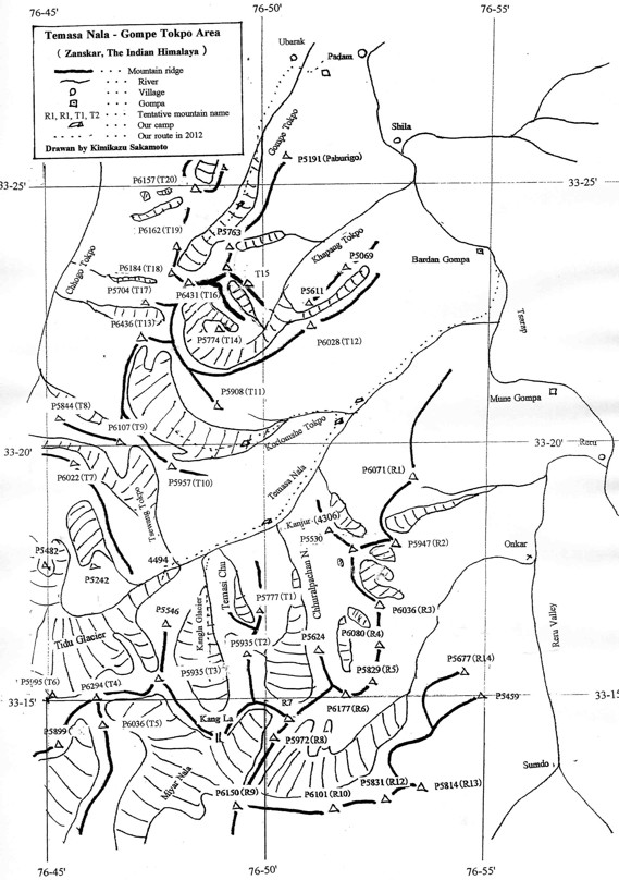
There is no official mountain name given to the peaks in Southern Zanskar. In order to avoid any confusion in identifying the mountains, we put our tentative mountain names like T1, T2, T3 to the peaks in Temasa Nala and Gompe Tokpo, H1, H2, H3 to the peaks in Haptal Tokpo and M1, M2, M3 to the peaks in Mulung Tokpo. The outline maps drawn by myself are showing the tentative names.
2. Exploration of Temasa Nala :
July 5 (Thursday):Cloudy
6:55/Bardan Gompa School (3635m)- 8:20/Col of traverse hill - 12:40/Meadow before Korlomshe Tokpo (3945m).
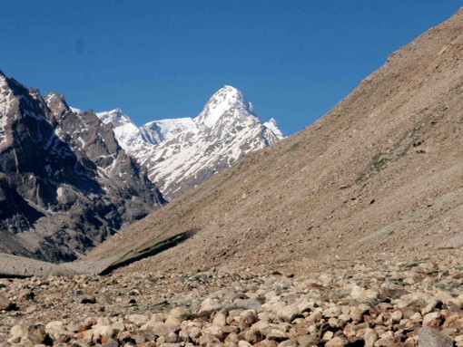
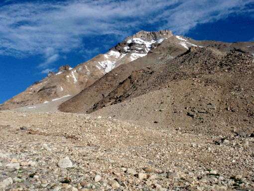
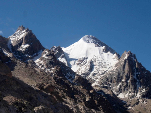
Today is the first day of our exploration to Temasa Nala. From Bardan Gompa School, we could see the exciting east face of P6071(R1) glittering in the morning sunrise. We walked up the gentle green pasture hillside and crossed three small hills. Then we walked down to the right side bank of Temasa Nala.
Temasa Nala was open and wide valley with about 200 ~ 300m width. Both side banks of the river were the very wide and flat meadow suitable for grazing yaks. But, the stream of Temasa Nala was so rapid and strong and seemed to be impossible for our crossing even by riding on horse.
Temasa Nala welcomed us with many beautiful flowers, like pink wild rose, blue poppy, yellow Hichu and etc. We could see the rock mountain P6028(T12) on the right side and the north face of P6071(R1) on the left side.
We came to the nice grassy meadow before the junction with Korlomshe Tokpo and decided to use this place for our camping site as we could get pure water.
 |
|
P6071 (R1) East Face, photographed from Bardan Gompa School.
|
July 6 (Friday) : Fair
7:00/CS before Kolromshe Tokpo (3945m) - 11:50/Kanjur (Junction with Chhuralpachan Nala) - 12:30/Near junction with Kangla Glacier (4200m).
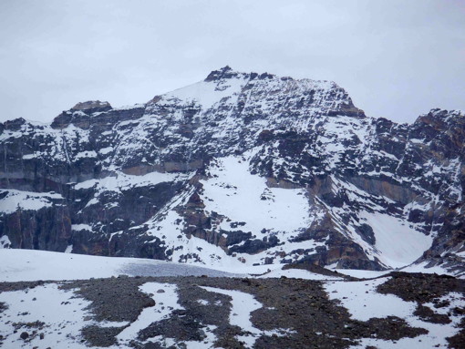
In the beautiful fair weather, we enjoyed the pleasant walking on the right bank of Temasa Nala, looking up the north face of P6071(R1) and P6028(T12).
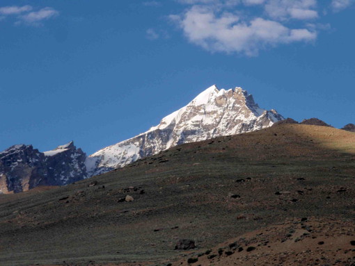
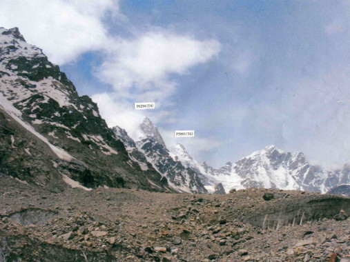
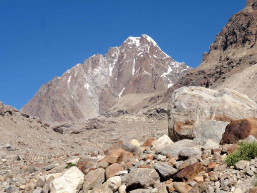
P6294(T4) on Tidu Glacier appeared behind the junction with Kangla Glacier. Google Earth 3D photo showed this mountain as the white snow mountain. But, the actual peak of P6294(T4) which we saw from Temasa Nala was the pyramidal sharp peak mixed with rock and snow.
We pitched our tents at the wonderful green pasture just after passing Kanjur which was located at the junction with Kangla Glacier, as we could have the pure spring water. Many yaks were enjoying in eating grasses and walking around near our camp site.
 |
 |
|
P6071 (R1) North Face, photographed from Temasa Nala
|
P6294 (T4) =center, and P5995 (T6) = right
|
July 7 (Saturday) : Fair and Cloudy
7:30/CS near junction with Kangla Glacier (4200m) - 9:15/Junction with Kangla Glacier - 0:30/Glacier tongue of Tidu Glacier - 14:10/Near Junction with Tsewang Tokpo (4400m) - 18:00/CS near junction with Kangla Glacier (4200m).
We had one day hiking to Tidu Glacier. The glacier tongue looked not so far from our camp site, but actually it took three hours for us to reach there. We climbed up to the center of the moraine from the glacier tongue and walked around on the moraine avoiding many crevasses.
It took a lot of time in maze of moraine until we reached near the junction with Tsewang Tokpo which went up to the North Glacier where P6107(T9) and P6022(T7) were located.
On the left side of Tidu Glacier, there were the attractive peaks P6294(T4) and P5995(T6). But both mountains looked difficult to be climbed.
Originally, we planned to go up Tsewang Tokpo to see P6107(T9) and P6022(T7) in three days trekking, carrying up camping equipments and foods by horses. However, we found that it was impossible to carry up the heavy baggages by horses into the Tsewang Tokpo, because it was steep with several water falls and the side slopes was also so steep and dangerous with unstable stones for horses. Therefore, we gave up this exploration program into Tsewang Tokpo.
It took us long time to go down on the unstable moraine to the glacier tongue. We came back to our camp site at 18:00, being fatigued.
 |
|
P6294 (T4) and P5995 (T6) in Tidu Glacier of Temasa Nala
|
July 8 (Sunday) : Cloudy and fine. Rest day
We decided to take rest for full day, as Mr. Katsumata was not in good condition with heavy cough and phlegm and his face was swollen. And other members were also tired after hard working on the previous day. We spent this rest day for washing clothes and reading book.
On the other side from our camp site, there was Chhuralpachan Nala, the big branch of Temasa Nala which goes up South to P6177(R6). There was the big rock castle on the left side of Chhuralpachan Nala. It was the junction peak which was located on the main ridge between P5947(R2) and P6036(R3). This peak has no height on the Indian Official Map but seemed to be around 5800 ~ 5900m. I wondered any young climbers will try to challenge this rock castle peak in the near future.
In the afternoon, our guide Tsewang and one horseman went to Kangla Glacier for reconnaissance to find how far the horses could carry up three-days baggages to attack Kang La (5468m). They reported us that the highest point for their horse transportation would be up to about 4500m where the glacier started. Therefore, we decided to go up Kangla Glacier as far as possible in one-day hiking, giving up to set up our attack camp around 5000m to Kang La.
July 9 (Monday) : Fair
8:00/CS near junction with Kangla Glacier (4200m) - 9:30/Junction with Kangla Glacier - 10:30/Right side mountain - 12:20/CS (4200m)
As Mr. Katsumata had the high fever with 38.6 Celsius, other three members had the short hiking to the right side mountain in Temasa Nala to see the inside of Kangla Glacier. We climbed up grassy slope with faint yak trail. We saw the other side of Temasa Nala and recognized that Kangla Glacier was big and long.
July 10 (Tuesday) : Cloudy and then fair
5:00/CS (4200m) - 6:00/Junction with Kangla Glacier - 8:05/Kangla Glacier 4530m - 10:45/Kangla Glacier 5000m - 12:40/Junction with Kangla Glacier - 15:40/CS(4200m).
Three members and Tsewang, our guide, left the camp site at 5:00am to have one day hiking to Kangla Glacier, as Mr. Katsumata still had heavy cough and phlegm.
Two horsemen came with us to the junction to assist us to cross Temasa Nala on horses. Even in the early morning, the stream was very strong and rapid. There was the yak trail on the left side gentle slope of Kangla Glacier, with several cairns up to about 4500m where the glacier started. Mr. Okabe and Mr. Shibata went ahead as they were fast walkers, and Tsewang and I enjoyed the slow walk.
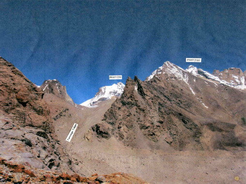
When we looked back the other side of Temasa Nala, we could see P6107(T9) in Tsewang Tokpo and P5957(T10).
When we walked up on the glacier over 4500m, we could see the beautiful snow and rock mountain P5995(T3) on the right side and the top of Kangla Glacier. I took several photographs of the mountains on the left side of Kangla Glacier, but unfortunately we could not identify which peak was P5935(T2).
I and Tsewang turned back from about 5000m where the glacier became flat, and Mr. Okabe and Mr. Shibata went up to about 5100m.
When we went down to the junction, Temasa Nala had so much water with melted glacier and became so rapid and strong. We went up near the glacier tongue of Tidu Glacier and crossed the rather shallow spot on horse. After we came back to the camp site, the rock castle on the left side of Chhurapachan Nala was glittering in the sunset.
 |
 |
|
P5935 (T3) in Kangla Glacier
|
Top of Kangla Glacier
|
 |
|
|
P6107 (T9) and P5957 (T10) photographed from Kangla Glacier
|
|
July 11 (Wednesday):Fair and then cloudy
7:50/CS (4200m) - 9:40/Nyusri Yonga - 11:00/Korlomshe Tokpo (4020m).
We moved down to the junction with Korlomshe Tokpo for our exploration into Korlomshe Tokpo. We pitched our tents at the nice beautiful place with pure water on the left side of Korlomshe Tokpo.
 |
 |
|
Junction rock peak, P6036 (R3) and P6080 (R4) in Chuuralpachan Nala
|
Junction Big Rock Peak in Chuurapachan Nala
|
July 12 (Thursday): Cloudy
7:05/CS at junction with Korlomshe Tokpo (4020m) - 8:20/Korlomshe Tokpo 4195m - 11:00/Korlomshe Tokpo 4525m.
We walked up from our camp site on the left side of Korlomshe Tokpo and crossed over the stream to the right side after walking up about 500 meters. We climbed up the rather unstable slope with many rocks on the right side of the stream. The two branches came down from the rock mountain P6028(T12) at the turning corner (4195m) of Korlomshe Tokpo.
Our horseman carried up our equipments and three days foods on horses and refused to go up further, unloading all baggages at about 4500m. The horseman excused that the rough slope with many stones was very dangerous for his horses. We tried to persuade him to go up further at least up to 4800 ~ 5000m for our exploration into the top of Korlomshe Tokpo. But, he strongly refused our request by claiming our compensation with Rs50,000 if his horse was injured. He went down to the entrance of Korlomshe Tokpo with horses, saying that he would come back to fetch our baggages on July 14. We were obliged to stay at 4525m, with much frustration.
 |
|
P6028 (T12) from Korlomshe Tokpo
|
July 13 (Friday) : Fair and then cloudy and rainy
6:10/CS (Korlomshe Topko 4525m)- 9:00/4925m at bottom of P5908(T11) - 10:10/5100m -13:45/CS (4525m).
We went up Korlomshe Tokpo all together. The steep slope from our camp site was not so bad. We felt that all horses could go up surely safely.
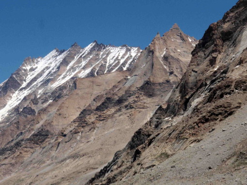
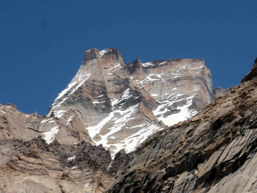
At the corner of Korlomshe Tokpo which turns to right, P5908(T11) was located on the right side. On the left side, the sharp rocky peak P5957(T10) stood up overwhelming us.
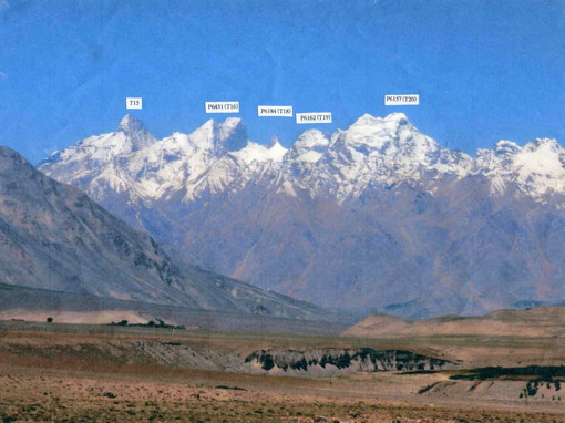
The wide and big Korlomshe Glacier turned to the right. The fair weather suddenly changed to cloudy and the mountains started to be covered with thick mist. Mr. Okabe and Mr. Shibata rushed to the upper glacier to take photographs of P6436(T13) which is the highest mountain in this area. At around 5100m, they could take only one photograph to show the whole figure of P6436(T13) which was the big rock face mountain.
On our way back to our camp site (4525m), we found the good camping spot at around 4800m, which might be Base Camp for P6436(T13). We came back to our camp site before rain came.
 |
 |
|
P5957 (T10) in Korlomshe Nala photographed by Mr. Okabe
|
P5908 (T11) in Korlomshe Tokpo
|
 |
|
|
P6436 (T13) in Korlomshe Tokpo phtographed by Mr. Okabe
|
|
July 14 (Saturday) : Cloudy
8:20/CS (4525m) - 11:40/CS at junction with Korlomshe Tokpo (4020m).
We walked down on the left side of Korlomshe Tokpo, enjyoing many beautiful wild flowers including many blue poppies.
July 15 (Sunday): Cloudy
7:45/CS (4020m at junction with Korlomshe Tokpo) - 13:30/Bardan Gompa School (3635m).
We walked down to Bardan Gompa School, saying goodby to Temasa Nala. In the afternoon, we visited Bardan Gompa where the big black Tibetan dog welcomed us at the entrance.
July 16 (Mon) : Fine
7:30/Bardan Gompa School - by car - 8:20/Chaming Karsha Hotel And Restaurant at Padam.
We moved back to Padam by chartered cars. Mr. Katsumata went to Padam Clinic Center as he was still suffering cough and phlegm. The doctor examined him carefully, and said that there was
nothing serious on him and that he could continue trekking.
The clinic charge claimed was only Indian Rs2 as Doctor's examination fee and two medicines
charges. According to the explanation by our guide Tsewang, clinic charge in Zanskar is specially very cheap because of Indian Government Medical Project to support Zanskar territory.
Our horsemen and ten horses would stay near Khapang Tokpo and join us at Ubarak in the morning of July 17, as their horses could not spend the night in the town of Padam.
3.Exploration to Gompe Tokpo :
July 17 (Tuesday) : Fair
7:00/Hotel at Padam - 8:00/Junction with Gompe Toko - 9:00/Ubarak village - 15:30/Gompe Tokpo 4510m.
We walked up the gentle slope from the town of Padam to the entrance of Gompe Tokpo.
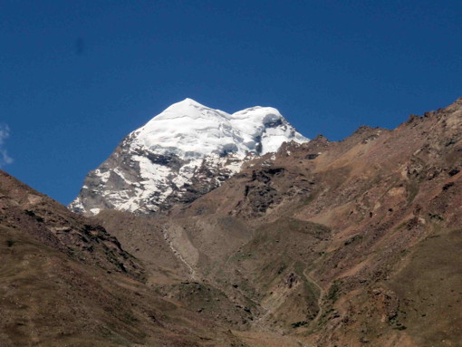
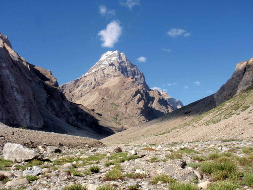
P6157(T20) which is the symbolic mountain of Padam stood up on the right side of Gompe Tokpo. We turned to right at the entrance of Gompe Tokpo to Ubarak. The traverse road to Ubarak village was very beautiful, decorated with many colorful wild flowers.
We took yak trail on the grassy slopes from Ubarak village and traversed to the left side until we reached the col on the ridge with the cairn, where we could look down Gompe Tokpo.
We went down the steep gully 40 ~50 meters from the col and then traversed the tricky unstable pile of big rocks to the right side for about 30 minutes. Then we entered into the branch of Gompe Tokpo. It was exhausted work.
We climbed up the steep gully. After crossing over several small hills, finally we reached the flat spot where the upper Gompe Tokpo started. We set up our camp site on the grassy flat meadow with the blue poppies.
July 18 (Wednesday) : Fair
7:00/Gompe Tokpo 4510m - 7:55/Col with big cairn - 9:07/Gompe Tokpo 4720m - 12:10/Gompe Tokpo 4920m - 17:15/Gompe Tokpo CS 4510m.
We walked up on the gentle moraine from our camp site and reached the col with the big cairn
which might be built by village people pasturing yaks.
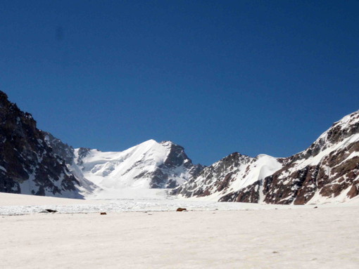
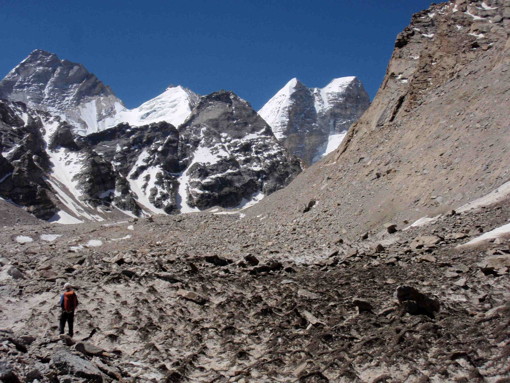
After crossing over the col, Gompe Tokpo became wider and the glacier started being surrounded with the overwhelming peaks. It was the amphitheater of Gompe Glacier.
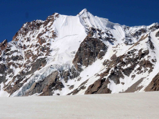
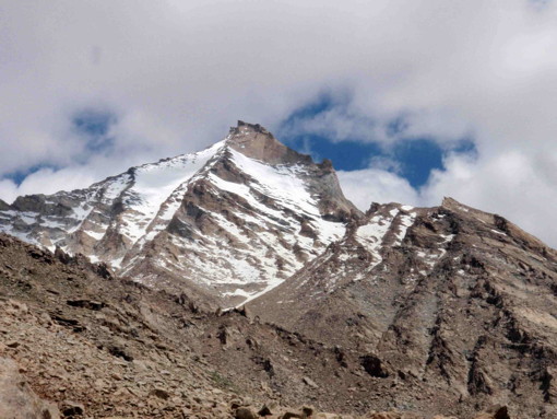
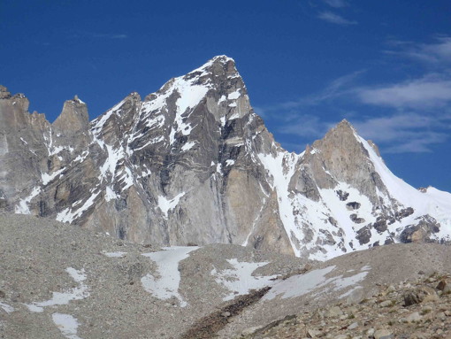
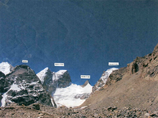
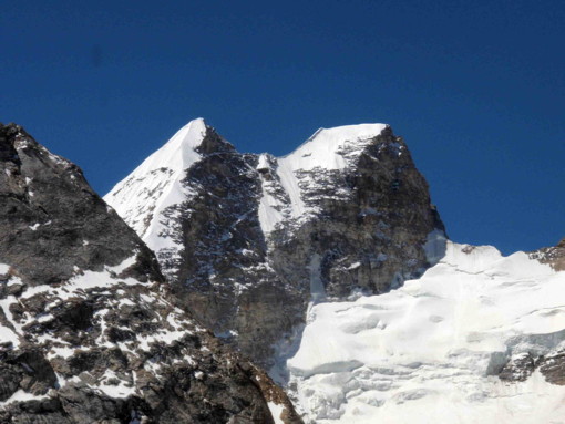
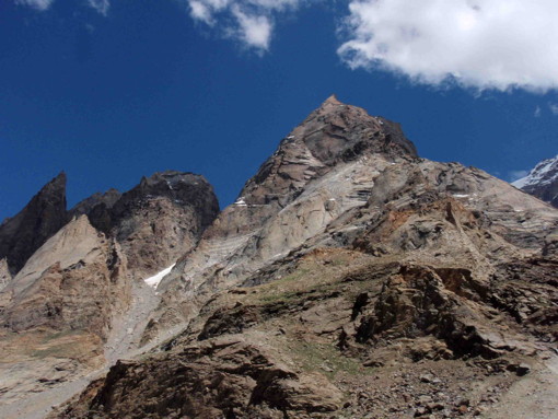
On the left side of the glacier, there was the big twin rock peak P6431(T16). At the top of Gompe Glacier, the slender rock pinnacle peak P6184(T18) stood. There was P6162(T19) on the right side. We could not see P6157(T20) from the inside of Gompe Glacier.
To the left of P6431(T16), T15 which has no official altitude on the map stood like Matterhorn in Zanskar.
We wondered why no climber came up to this sanctuary of Gompe Tokpo to climb such attractive peaks which could be seen easily from Padam and Thonde.
 |
 |
|
Unknown peaks in Gompe Tokpo photographed near Thonde Gompa
|
P6157 (T20) photographed from Padam
|
 |
 |
|
Veiled virgin peaks in Gompe Tokpo
|
P6431 (T16) in Gompe Tokpo
|
 |
|
|
T15 = left, P6431(T16) = right in Gompe Tokpo
|
|
July 19 (Thursday) : Fair
7:45/Gompe Tokpo CS (4510m)- 9:32/Col to Ubarak - 12:10/Ubarak village (3800m).
Our kitchen staff found the short cut route to Ubarak village. We traversed rather steep slope with many piled rocks. We had to be careful not to fall into the hole of piled rocks and then walked up the unstable slope to the col where we could see Ubarak village.
On our way down to the village, we met Nepal man pasturing goats. Our camp site was on the grassy meadow near Ubarak village, with many beautiful wild flowers.
We visited the house of Ubarak School teacher and gave her the photographs which I took last year. Several small children came to our camping site from Ubarak village and stayed with us until nightfall.
4. Exploration of Haptal Tokpo :
July 20 (Friday) : Fair
7:15/Ubarak CS (3800m) - 9:55/Junction with Haptal Tokpo - 12:30/Haptal Tokpo(3655m).
As we could not explore into Tsewang Tokpo and we used only one day in Kangla Glacier instead of three days, six free days were left for us before our leaving for Leh. We decided to move to Chhogo Tokpo, the branch of Haptal Tokpo, to see the west side of P6157(T20), P6162(T19), P6184(T18), P6436(T13) and P6107(T9).
We traversed several pastures of the other villages, Razan, Trachhumik, Gomba and Taran, and went to Hapatal Tokpo. We crossed the strong big bridge on the main traffic road between Kargil and Padam to the right side of the valley. There was the small hydroelectric power station on the right side hill. Haptal Tokpo was the wide and open valley with the big grassy flat banks on the both sides, where many yaks were grazing. We saw the big rock peak P5845(H17) standing firmly at the junction with Chhogo Tokpo.
The water canal was built to supply the valley water to the hydroelectric power station. There was the big flat place like a football ground with a small refuge hut. Our guide Tsewang said that this hut might be built for trekkers just as propaganda for tourism by Indian Government, even though the trekking route from Haptal Tokpo to Kishtwar via Omasi La was seldom used.
We walked along the water canal and climbed up the right side bank at the starting point of the water canal. There was the green flat meadow with many stone yak huts. We decided to pitch our tents, as there was pure spring water.
.jpg)
 |
|
P5845 (H17) in Chhogo Tokpo of Haptal Tokpo
|
July 21 (Saturday) : Fair
7:20/CS (Haptal Tokpo yak huts 3665m) - 9:15/Tepuk Bhu (Junction with Chhogo Tokpo) - 12:20/Junction with Satachan Tokpo (3850m).
As the stream of Haptal Tokpo was so strong with much water, it seemed to be so dangerous for us to cross the stream from the right side to the left side to get into Chhogo Tokpo, even by using horse. Therefore, we decided to give up our plan to explore Chhogo Tokpo and to go up the main valley to Haptal Glacier.
After passing Tepuk Bhu, the junction with Chhogo Tokpo, the mountains with sharp rock pinnacle appeared on the both sides of Haptal Tokpo.
At the bottom of Haptal Tokpo, we could see P5740(H14) and P5840 (H15) at the junction with Haptal Glacier and Yurachuk Glacier. We camped at the junction with Satachan Tokpo.
 |
|
P5740 (H14) = right, P5860 (H15) = left in Hapatal Tokpo
|
July 22 (Sunday) : Fair
6:30/CS at junction with Satachan Tokpo (3850m) - 8:05/Junction of Haptal Glacier and Yurachuk Glacier - 12:20/Haptal Glacier 4500m - 14:50/CS at junction with Satachan Tokpo.
Four members and our guide Tsewang left our camp site at 6:20am to the junction of Haptal Glacier and Yurachuk Glacier.
We judged it was dangerous for us to cross Haptal Tokpo from the right side to the left side in order to get into Yurachuk Glacier, because the stream was too rapid. The glacier tongue of Yurachuk Glacier was located near the valley junction, and Yurachuk Glacier seemed to be very rough with many crevasses. Therefore, we gave up to explore Yurachuk Glacier and decided to go up Haptal Glacier.
We climbed up the steep grassy slope on the right side, escaping several water falls to reach the plateau. We could find the faint yak trail on the right side of the Haptal Glacier.
At the corner of Haptal Glacier which turned to left, there was the rocky peak P5775(H13). Though there should be P6042(H3) in the right side branch, it was hidden by the front mountain.
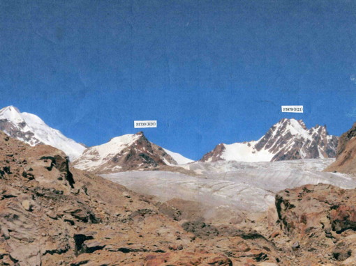
Haptal Glacier became wide and open after it turned to left. We could see P5730(H20) and P5878(H21) at the top of Haptal Glacier.
When we looked back to Yurachuk Glacier, we could see the beautiful white peak P5849(H16) on the left side of Yurachuk Glacier. We turned back from around 4500m and went down to the junction. Many yaks were gathering at the junction and enjoying in grazing on the both side banks of Haptal Tokpo.
We came back to our camp site, looking the challenging rock pinnacles on the both side of the valley.
 |
 |
|
P5840 (H16) in Yurachku Glacier of Haptal Tokpo
|
P5775 (H13) in Haptal Glacier
|
 |
|
|
P5878 (H21) and P5730 (H20) in Haptal Glacier
|
|
July 23 (Monday): Cloudy
6:45/CS at junction with Satachan Tokpo (3850m) - Satachan Tokpo - 9:35/CS(3850m).
We tried to explore Satachan Tokpo to see P6085(H2) and P6042(H3). As I was not in good condition, I gave up to go farther at the water fall. Three members and Tsewang continued to climb up the left side slope. But, they encountered the gorge and were obliged to retreat without seeing P6085(H2) and P6042(H3). They came back to our Camp Site at 9:35am.
 |
 |
|
Pinnacle rocks in Haptal Tokpo
|
Rock mountains in Hapatal Tokpo
|
July 24 (Tuesday) : Cloudy
7:35/CS at junction with Satachan Tokpo (3850m) - 11:30/yak huts CS (3655m).
It was possible for us to go down to Sani village in one day, but we preferred to spend another night in the quiet mountains because the camping site at Sani village might be noisy.
All of us including our kitchen staffs and horsemen were busy in the afternoon for washing, as we don't want to wear the dirty and sweaty clothes in the town.
We had the farewell party in the evening, as two horsemen and one kitchen staff would be going back to their village soon after arrival at Sani village on June 25.
July 25 (Wednesday) : Cloudy then fine
7:35/CS at junction with Satachan Tokpo (3850m) - 9:30/Camping site at Sani village (3500m).
We went down to Sani village and pitched our tent at the camping site on Sani Lake. Two horsemen and one kitchen staff left for their home village, saying goodby to us. We visited Sani Gompa which would have festival soon. As village people continued training of drums for the festival until midnight around 2:00am, we could not have enough sleep.
5. After exploration :
We spent three days during July 26 ~28 to return to Leh via Kargil.
On July 29, we enjoyed attending at Daktok Gompa Tsechu (festival) and visiting Chemrey Gompa and Spitok Gompa.
On July 30, we left Leh for Delhi and visited IMF Head Office in the afternoon. We had the nice meeting with the Director Mr. J P Bhagatjee. He appreciated our exploration in Zanskar and expressed his thanks for our effort to introduce the hidden peaks in Zanskar to the climbers over the world through The Himalayan Journal, Japanese Alpine News and etc.
In our 2012 exploration to Temasa Nala, Gompe Tokpo and Haptal Tokpo, we could see and identify the twenty-one virgin peaks as below.
| P6071(R1) | Non Open Peak | P5935(T3) | Non Open Peak | |
| P6294(T4) | Open Peak | P5995(T6) | " | |
| P6107(T9) | " | P5957(T10) | " | |
| P6028(T12) | " | P5908(T11) | " | |
| P6436(T13) | " | P5845(H17) | " | |
| P6431(T16) | " | P5740(H14) | " | |
| P6184(T18) | " | P5860(H15) | " | |
| P6162(T19) | " | P5840(H16) | " | |
| P6157(T20) | " | P5775(H13) | " | |
| P5878(H21) | " | |||
| P5730(H20) | " |
Above peaks have no climbing record on IMF book. But it is a real headache for IMF that recently illegal climbing without official IMF Permit has been increasing in Indian Himalaya.
We were very happy to have the successful exploration in the good team harmony and under the best support from our agent Hidden Himalaya.
We hope somebody will try to climb the virgin peaks which we found in this area.
.jpg)
.jpg)